Going on a long, peaceful hike in nature is beneficial to your mind, body, and soul. This is our preferred activity for staying fit and happy.
Tongariro National Park has a number of excellent trails that can be completed in a few hours or days. These trails will quench your thirst for adventure and fulfil your longing for the great outdoors.
This volcanic area is known for its rich history, beautiful scenery, clean rivers, and Australasia’s largest freshwater lake. It also has a strong Maori culture, making it one of the most fascinating hiking destinations. There are more scenic walks in New Zealand than anywhere else. Your hosts are hiking enthusiasts. Garth and Angie will gladly assist you in selecting the best walks for your level of fitness and available time.
National Park Tongariro
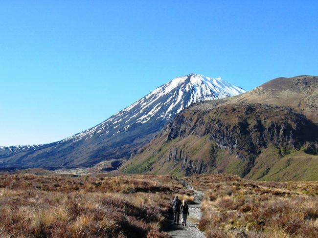
The Tongariro Alpine Crossing is a must-see on any list of Tongariro National Park walks. This is one of the most popular hikes in the park. It is 19.4 kilometres long and passes through an active volcano. It is surrounded by breathtaking scenery and landscapes. Here you will find detailed information on hiking the Tongariro Alpine Crossing in both summer and winter.
This is one of New Zealand’s oldest national parks, and it has been designated as one of 28 World Heritage Sites by UNESCO. The volcanic plateau of the Central North Island is home to three volcanoes. They are the result of two million years of tectonic plate movement. The Tongariro Crossing is accessible all year, but winter is the best time to bring your snowshoes and mountaineering equipment. The Tongariro Alpine Crossing is an excellent day hike that leads to the famous Emerald Lakes. Or, for a multi-day hike, take the Tongariro North Circuit. All three active volcanoes, as well as their historical lava flows, will be visible.
In the summer, Mount Ruapehu is a fantastic day hike to consider. In the winter, the mountain is well-known for its skiing, but in the summer, it transforms into a hiking paradise. Dome Ridge, the mountain’s summit, provides views of the crater lake. Look around for Ngauruhoe and Tongariro! Mount Ruapehu is suitable for fit and experienced hikers. If you are unsure, a local guide is recommended.
How to Get There: The Tongariro Crossing is easily accessible by car, public transportation, or private transportation. It’s about a 5-hour drive from Auckland or Wellington. The park’s main entrance is located in Whakapapa Village. Daily buses run between Ohakune, Taumaranui, and Turangi, taking you around the larger National Park area. More information is available on the Department of Conservation’s website.
This track is an excellent year-round alternative to the Tongariro Alpine Crossing and is ideal for those who have completed the Crossing. The Tama Lakes track winds through an undulating landscape of alpine herbfields and tussock. It’s a lot easier than the Crossing, with fewer ascents. The only exception is a steep climb to 1440m for a view of the upper lake. The views from this walk, which is framed by Mt Tongariro and Mt Ngauruhoe, are simply spectacular. Tama lakes are located in several volcanic explosion craters and are well worth the journey. This walk starts and finishes in Whakapapa Village. It also includes the lovely Taranaki Falls.
National Park Abel Tasman
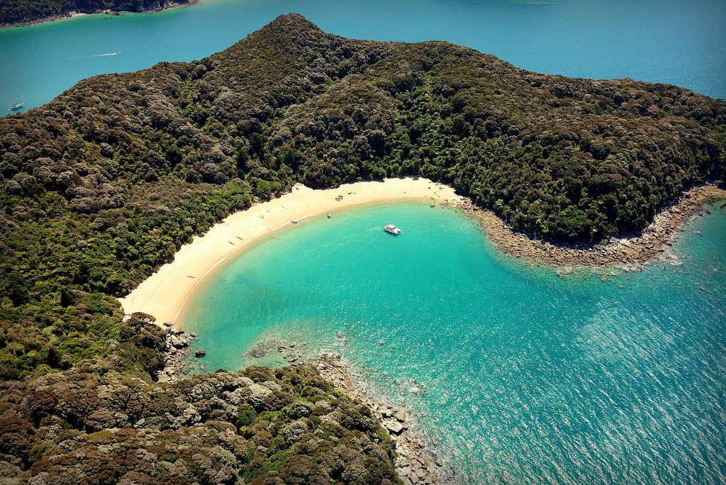
The Abel Tasman is the highest point on South Island, located west of Nelson. It’s a must-see if you’re driving around New Zealand in one of our JUCY campers. This coastal paradise is known for its golden sand beaches and a variety of great walks that last 3-5 days. The Abel Tasman National Park is New Zealand’s smallest at 22 hectares. Keep an eye out for wildlife such as blue penguins, gannets, and fur seals if you’re lucky! The unique granite rock formations, beautiful beaches, and natural rock pools will astound you.
There are bus services from Nelson as well as nearby towns such as Kaiteriteri, Takaka, Motueka, and Takaka. There are also water taxi services available. More information is available here.
National Park of Aoraki/Mount Cook
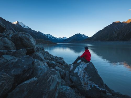
Aoraki National Park, which includes Mount Cook, New Zealand’s highest peak, is one of the most visited parks in the country. There are activities for everyone, such as multi-day hikes, day walks, and mountain biking. You can also relax and gaze at the stars while admiring the breathtaking scenery. The only dark-sky reserve in New Zealand is Aoraki Mount Cook National Park. Maori legends and history abound.
Aoraki/Mount Cook National Park is located in central South Island’s Southern Alps. It’s about a 4-5-hour drive from Christchurch and about a 3-hour drive from Queenstown. More information is available on the Department of Conservation’s website.
Westland National Park Poutini Tai
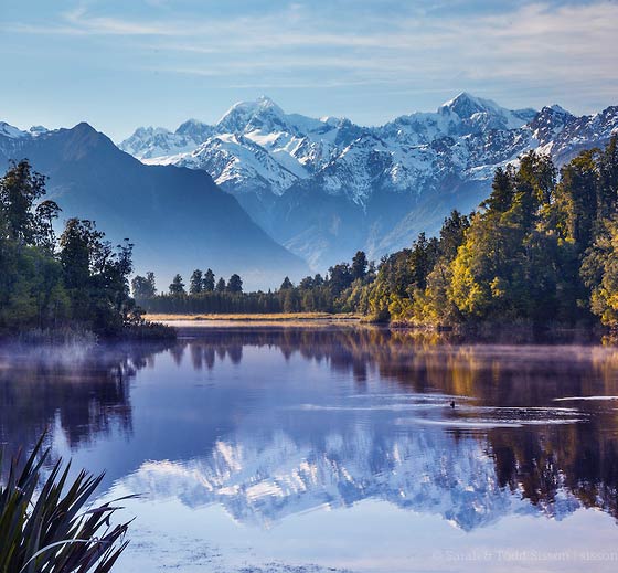
Aoraki Mount Cook National Park is close to Westland Tai Poutini. It is home to two of New Zealand’s most famous glaciers, Fox Glacier and Franz Josef Glacier. This UNESCO World Heritage Site stretches from the Southern Alps to the wild West Coast beaches. It also includes rare flora, fauna, wildlife, and information about our natural history. One of the most well-known hiking trails is the Copland Track. It links the Westland Tai Poutini National Park to the Aoraki Mount Cook National Park. The Welcome Flat hot springs are one of the track’s main natural attractions. If you’re driving down the West Coast or visiting Aoraki Mount Cook National Park, stop by Westland Tai Poutini National Park.
How to get there: State Highway 6 connects Hokitika and Haast to the park. Along the West Coast, regular bus services are available. However, we recommend that you check the Department of Conservation website for any closures or alerts.
Fiordland National Park
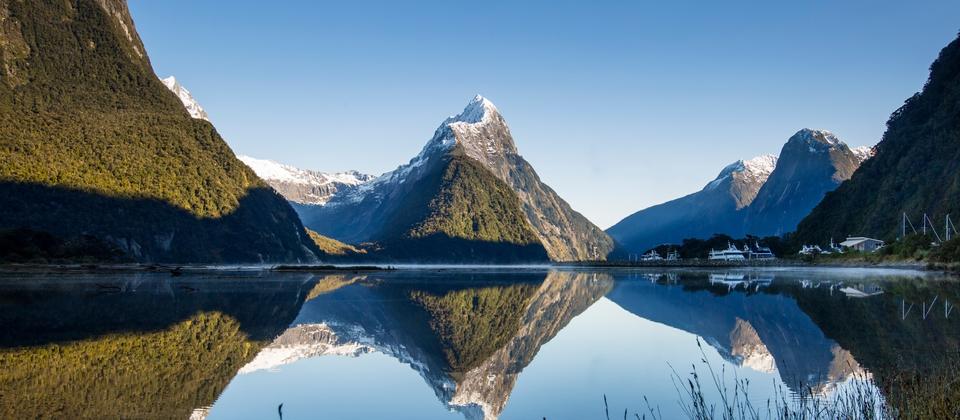
Queenstown and the Lower South Island are fantastic destinations. The Fiordland National Park is home to many of our wonderful walks. The park contains a number of breathtaking sights, including waterfalls, lakes, rainforest, and mountain peaks. The park’s fourteen fiords have been around for approximately 100,000 years. They also include the most recent ice age, which took place around the same time.
The 1.2 million-hectare park is home to endangered species such as the Takahe. The Department of Conservation is in charge of it. The Routeburn Track and the Milford Tracks, two of Fiordland’s most famous and spectacular walks, provide unrivalled views. Hikers should go during the summer months to get the best views.
The Fiordland National Park can be reached by road, boat, or plane. If you’re driving, Te Anau will be your first stop in Fiordland. The best routes to Invercargill are State Highway 1 and State Highway 94. Queenstown is accessible via State Highways 6 and 94. More information about alternative modes of transportation can be found here.